
geoportail.lu
4.0star
130 reviews
10K+
Downloads

Everyone
info


About this app
The official mapping app from Luxemburg’s national geoportal, developed by the Cadastre & Topography Administration (ACT).
This app enables you to view topographic maps, aerial photos, and cadastral parcels as well as many other interesting datasets about Luxemburg via your mobile device.
✓SEARCH FOR PLACES: Search for places by names, toponymes, parcel numbers, coordinates etc…
✓Chose among more than 100 different data layers (as available on our website http://map.geoportal.lu)
✓Share your maps
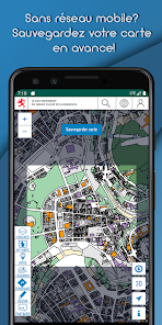
✓ Use maps in offline mode
!
Offline functionality:
Choose a specific zone to download to your device. The active map layers for this area will be available to use even when offline, for example when hiking in areas without network coverage. This functionality is also ideal to download our maps via Wi-Fi at home, without incurring excessive mobile data download charges or exceed your data quota.
!
✓ ACCESS QUALITY TRAILS
✓VISUALIZE HEIGHT PROFILES
✓ ENJOY A LOT OF OTHER FUNCTIONS
✓ create POIs on the map (thanks to the GPS, by coordinates , e.g Geocaching or inventories )
✓ Export GPX/KML files
WARNING: Continued use of GPS running in the background can dramatically decrease battery life. Continued use of maps in online mode may lead to unexpected costs due to high download traffic.
Check our PRIVACY POLICY at:
https://geoportail.lu/en/applications/mobile-apps/privacy-policy
This app enables you to view topographic maps, aerial photos, and cadastral parcels as well as many other interesting datasets about Luxemburg via your mobile device.
✓SEARCH FOR PLACES: Search for places by names, toponymes, parcel numbers, coordinates etc…
✓Chose among more than 100 different data layers (as available on our website http://map.geoportal.lu)
✓Share your maps
✓ Use maps in offline mode
!
Offline functionality:
Choose a specific zone to download to your device. The active map layers for this area will be available to use even when offline, for example when hiking in areas without network coverage. This functionality is also ideal to download our maps via Wi-Fi at home, without incurring excessive mobile data download charges or exceed your data quota.
!
✓ ACCESS QUALITY TRAILS
✓VISUALIZE HEIGHT PROFILES
✓ ENJOY A LOT OF OTHER FUNCTIONS
✓ create POIs on the map (thanks to the GPS, by coordinates , e.g Geocaching or inventories )
✓ Export GPX/KML files
WARNING: Continued use of GPS running in the background can dramatically decrease battery life. Continued use of maps in online mode may lead to unexpected costs due to high download traffic.
Check our PRIVACY POLICY at:
https://geoportail.lu/en/applications/mobile-apps/privacy-policy
Updated on
Safety starts with understanding how developers collect and share your data. Data privacy and security practices may vary based on your use, region, and age. The developer provided this information and may update it over time.

No data shared with third parties
Learn more about how developers declare sharing

This app may collect these data types
Device or other IDs

Data is encrypted in transit

You can request that data be deleted
Ratings and reviews
3.6
130 reviews

Alex Becker
- Flag inappropriate
May 9, 2023
The app has a lot of potential. Unfortunately not everything is working well. I drawed a card yesterday, now the same card (which I've saved in my account) is empty. You need to know (it's not explained) that you can delete points on your "line" by selecting it and then clicking on it again. It's possible to import gpx data but it's not possible to export you drawings as gpx, only as xml. If you enable you current location, you can't move the map. I could go on but I'm out of characters...

Maxim Weemaes
- Flag inappropriate
September 4, 2021
Error 503 unusable
1 person found this review helpful

A Google user
- Flag inappropriate
April 23, 2018
I was very happy to first find this app. It would be nice to add some
signal when leaving a path that I try to follow. Ok, now the app is not
working at all, very sad.
What's new
- Download our vectortile style maps to use them in offline mode
- Small bug fixes
- Small bug fixes
App support
phone
Phone number
+352449011